Our MOTIVATE-postdoc Tracy Hruska (University of Oulu) accompanied the fieldwork of Work Package 3 (University of Oviedo) in the wonderful mountains of Spain.
As part of Work Package 6, Tracy is documenting the methods, goals, as well as the social context, motivation, and personal experiences of botanical experts the perform the field work needed to study the local to global changes in vegetation and plant diversity.
Following two field campaings to resurvey vegetation records from 1987 and 2004-2005, Tracy has documented his experiences and observations below.
Tracy Hruska, Postdoc, University of Oulu (MOTIVATE WP6)
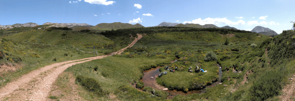
I start this missive from the Helsinki airport, during Juhannus, the Finnish midsummer holiday that this year (2025) falls on the summer solstice. I am on my way back to Oulu from nearly a week in Asturias, Spain, with the MOTIVATE WP3 group. I spent most of my time there with Alessandra Pollo, a visiting doctoral student from University of Turin (in Italy) who is studying change in mountain mires, both in the Alps and now in the Cantabrian Mountains that divide the regions of Asturias and Castilla y León. I accompanied Alessandra and various members of Borja Jiménez-Alfaro’s vegetation ecology group on three long days of plot resurveys at three different mire sites, pestering them with questions about details of their resurvey protocol and asking for observations about each site and its apparent changes since the first survey. Remarkably, they allowed me to ride back to Oviedo with them every day, rather than leaving me to fend for myself in the dramatic mountains.
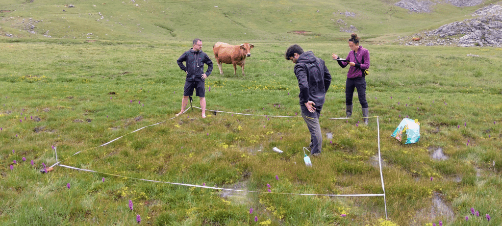
Alessandra is resurveying two different collections of sites; one was first sampled by Prieto and colleagues in 1987 and the second was sampled by Borja himself (with colleagues) in 2004-2005. The Prieto sites were easy to find, but there are no locations for the plots themselves, while Borja had a GPS point (with quality typical of that time) for each plot. This distinction proved important. The GPS points allowed us to relocate the correct patch of the mire for most resurveys with a fairly high degree of certainty, using the dominant species (usually 2-4, based on Braun-Blanquet cover class) from the previous survey to further refine the exact plot location. There were a few cases where apparent changes in vegetation community made us uncertain if we had found the right place. For the Prieto plots, on the other hand, there was little choice but to look for areas with the same dominant species and which matched the general physical label, such as “hummock” or “hollow”. This approach ensured that we found small patches of habitat that were similar in plant composition to the original surveys, though not identical.
In both types of resurveys, however, it was clear that our small plots were only capturing very specific species assemblages from a longer list present in each mire. With no photos or site descriptions to draw on, it was essentially impossible to determine how each mire overall had changed – though having Borja along at one site allowed for at least a basic, subjective comparison. Borja and Alessandra had accounted for that, and Alessandra’s study does not seek to describe changes to each mire based on plot data. Instead, her frame of analysis is the vegetation of bogs and of acidic and neutron-basophilous fens in the Cantabrian Mountains. The foremost aim is to verify that that no mires have disappeared – converted to other, drier habitat types, which is the greatest risk to these habitats (such as through climate change or hydraulic modification by people or landslides). Moreover, by pooling the mire sites together, she will look for changes at the regional scale, such as overall increases or decreases in types of species or in overall species richness. This limitation of analysis to larger spatial scales matches what I have heard from other researchers in MOTIVATE and from resurveyors at the University of Graz. If the plots were carefully marked permanent plots, this would be different, but quasi-permanent plots add too much uncertainty for one-to-one comparisons in most cases. Alessandra marked all of her plots with a sub-meter GPS so that any future resurveys would have the precise locations of her plots.
Alessandra will utilize remote sensing as a second source of data that can improve the interpretation of plot data at the site and regional scale. In GIS, she has the perimeters of approximately one thousand mires from throughout the Cantabrian Mountains digitized from aerial photographs, including all her mire resurvey sites. From remote sensing of those sites, she will collect some broad physical and biotic characteristics, such as soil moisture levels and plant productivity for each mire, enabling at least some possible explanations for species changes at the site and regional scale for as far back as the satellite imagery is available. But the coarse spatial resolution limits conclusions, and one would need a different data collection technique to monitor a specific mire over time in any real detail.
In a conversation with Borja, Luis Carlón Ruiz, and Jorge González Le Barbier back at the botanical garden in Gijón/Xixón, we discussed Alessandra’s methodology in the context of Habitats Directive monitoring and pairing survey data with remote sensing. It became clear that Alessandra’s ability to detect changes at the mire site level was hampered by the fact that all of her plots were quasi-permanent (only the approximate location from the previous survey was known), that the available remote sensing imagery dating back to Prieto’s study was only 30×30-meter resolution, and that the plots previously collected in all of the mires sampled only a portion of the sites and subjectively tried to sample “high-quality” vegetation associations only. While the original surveys did allow their respective investigators to characterize specific types of the region’s mountain mires, they were not established with long-term monitoring or resurveying in mind, and their utility in that regard is somewhat limited.
In discussion, and with much prodding from me, Borja made clear that one’s approach to surveying mires would be very different depending on purpose. If one were really interested in long-term changes of a single mire, the best option would be to start by creating a detailed map of the whole site – likely with hyperspectral drone imagery – and pairing the map with something like a grid of plots or transects covering the whole mire, with permanent locations.
But the level of effort per mire would be so high that this methodology could not be replicated at many sites. For national or regional monitoring of mires for the Habitats Directive, where the relatively coarse Annex 1 habitat classification system does not require the documentation of subtle shifts in relative abundance of typical species, a much simpler, and faster approach is called for. The simplest, fasted option would be for someone trained to identify Annex 1 mire habitat types to simply map the boundaries of the mire – and potentially any major vegetation groupings within – with a sub-meter GPS, and potentially collect one or a few (relatively large) permanent plots. Those details would be sufficient for pairing with relatively high-resolution satellite imagery to remotely monitor for significant changes in coming years.
This week in the field was part of WP6’s investigation into different ways of understanding vegetation communities and vegetation change. In the last month, I spent time in the field with plot surveyors and land managers in Italy (around Rome and Bologna), Austria (mostly around Graz), and now the Cantabrian Mountains. I may yet visit one more team this year, and will certainly embark on an additional series of field visits next spring.